Safety Rest Areas: Pecos West County Westbound
(Newly constructed facility opened February 2018)
Pecos West County Eastbound is the partner for Pecos West County Westbound
|
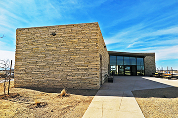 View of the new Pecos County Safety Rest Area |


Location
|
Features
Miscellaneous
- Newly contructed facility opened February 2018. The architectural design was inpired by local geological features, with folded rooflines that rhyme with silhouette of mountain ranges in the distance. The building is oriented for maximum view of the moutains from the lobby; after all this is the only mountainous area in Texas. The rectangular building masses are a metaphor of nearby undulating mesas, and the rugged building limestone walls resemble rock strata seen along nearby roadcuts. Outside, the landscaped dry creek with bridged sidewalks is a tribute to local natural water springs including the inactive Comanche Springs in Ft. Stocton, and the San Solomon Springs that supply water to the world's largest spring-fed swimming pool in nearby Balmorhea State Park.
- Fort Stockton, a town 30 miles east of the facility, was where a pre- and post-civil war cavalry fort located. Ninth United States Cavalry, a regiment of black troops (also known as "Buffalo'soldiers", as depicted on a wall at the eastbound facility) were among troops stationed here
- The name Pecos first appears in Juan de Oñate's reports concerning the Indian pueblo of Cicuye, now known as the Pecos Pueblo, and is of unknown origin